4178 Conference Road
Bellbrook, Ohio 45305
(937) 275-7275
Bellbrook, Ohio 45305
(937) 275-7275
Park Website:
http://www.metroparks.org/places-to-go/sugarcreek/
http://www.metroparks.org/places-to-go/sugarcreek/
Trail Map:
http://www.metroparks.org/wp-content/uploads/2016/01/MetroParks-Sugarcreek-Map-7-2016.pdf
http://www.metroparks.org/wp-content/uploads/2016/01/MetroParks-Sugarcreek-Map-7-2016.pdf
Campgrounds Nearby:
1. Frontier Campground (15 minutes away)- http://www.frontiercamping.com/
2. Caesars Creek State Park (21 minutes away)- http://parks.ohiodnr.gov/caesarcreek
1. Frontier Campground (15 minutes away)- http://www.frontiercamping.com/
2. Caesars Creek State Park (21 minutes away)- http://parks.ohiodnr.gov/caesarcreek
Pros: Bridle trails for horseback riding, wide and well-maintained trails, dog-friendly.
Cons: Some trails cross a river or creek which may be challenging after recent rain.
Cons: Some trails cross a river or creek which may be challenging after recent rain.
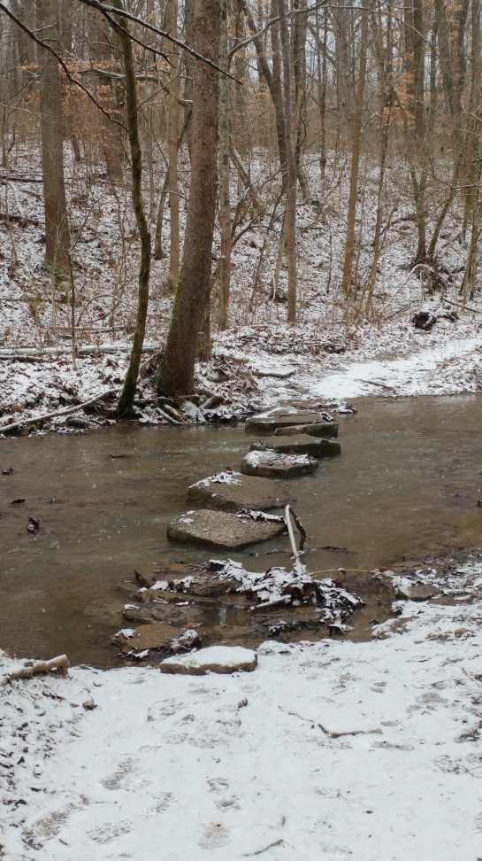
Sugarcreek Metropark is located in a suburb south of Dayton, Ohio. The Sugarcreek trail system is made up of seven different trails and a bridle trail that circumnavigates the perimeter of the park. The yellow trail is a .7 mile trail through prairie land on the south end of the park. A variety of bird species make their home here. The red trail is .5 mile hike through the Sycamore ridge where hikers can see deep ravines and a water source, hence, the Sycamore trees. The blue trail begins at the picnic shelter and follows Sugar creek, a decent size creek. The trail is approximately 1.3 miles. The biggest trail at Sugarcreek Park is the green trail which meanders through the eastern part of the park. Part of this trail follows alongside Sugar Creek. A small tributary creek of Sugar Creek runs north and south of the eastern side of the park. At two points along the green trail, hikers must cross the creek, which can be a bit of a challenge if it has recently rained and/or one is winter hiking.
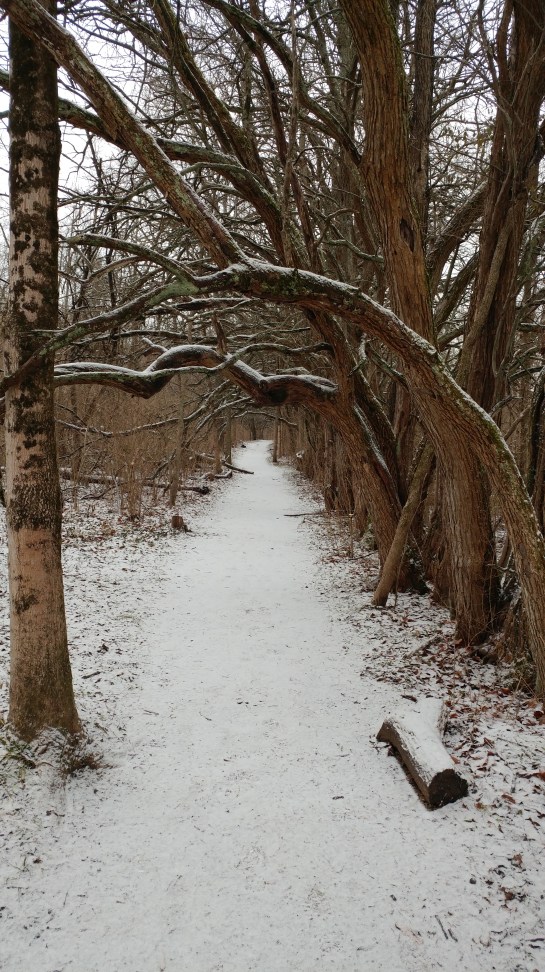
The orange trail is a 1.3 mile trail that is centrally located in the eastern side of the park. The orange trail includes two interesting features. The first is the Three Sister Oak Trees. Here, hikers can see white oak trees that are 550 years old! Sadly, one of the three sisters has fallen but the meadow and majestic trees are a nice photo site. Hike north of Three Sisters and you will see Osage Orange Tunnel. This “tunnel” is created by the arching branches of Osage Orange trees. The Planted Prairie trail is located adjacent to the parking lot. It is a short hike through tallgrass prairie. This trail is paved. During our visit at Sugarcreek, we did not explore the Big Woods Trail nor the bridle trail.

Overall, we really enjoyed our visit at Sugarcreek. We hiked the trails during the winter (December). It’s a great winter hike. However, be careful. It was icy when we went and often slipped as we hiked. Additionally, with two creek crossings, it can be risky skipping from one rock to the other to cross. All in all, we put in a little over 5 miles of hiking. Our favorite part of the trail system was the orange trail because of the Three Sisters oak trees and the Osage Orange tunnel. All of the trails were well-maintained and pretty wide.
